Reference · for Engineers, Operators
Online Map
A dashboard item that puts sites on a street or satellite map from their latitude and longitude, as markers, a route or both.
The Online Map puts each row of the data on a map from its latitude and longitude. Use it where location matters: plants and warehouses of one company, field sites, the stops of a route. The map zooms to fit all markers when it loads.
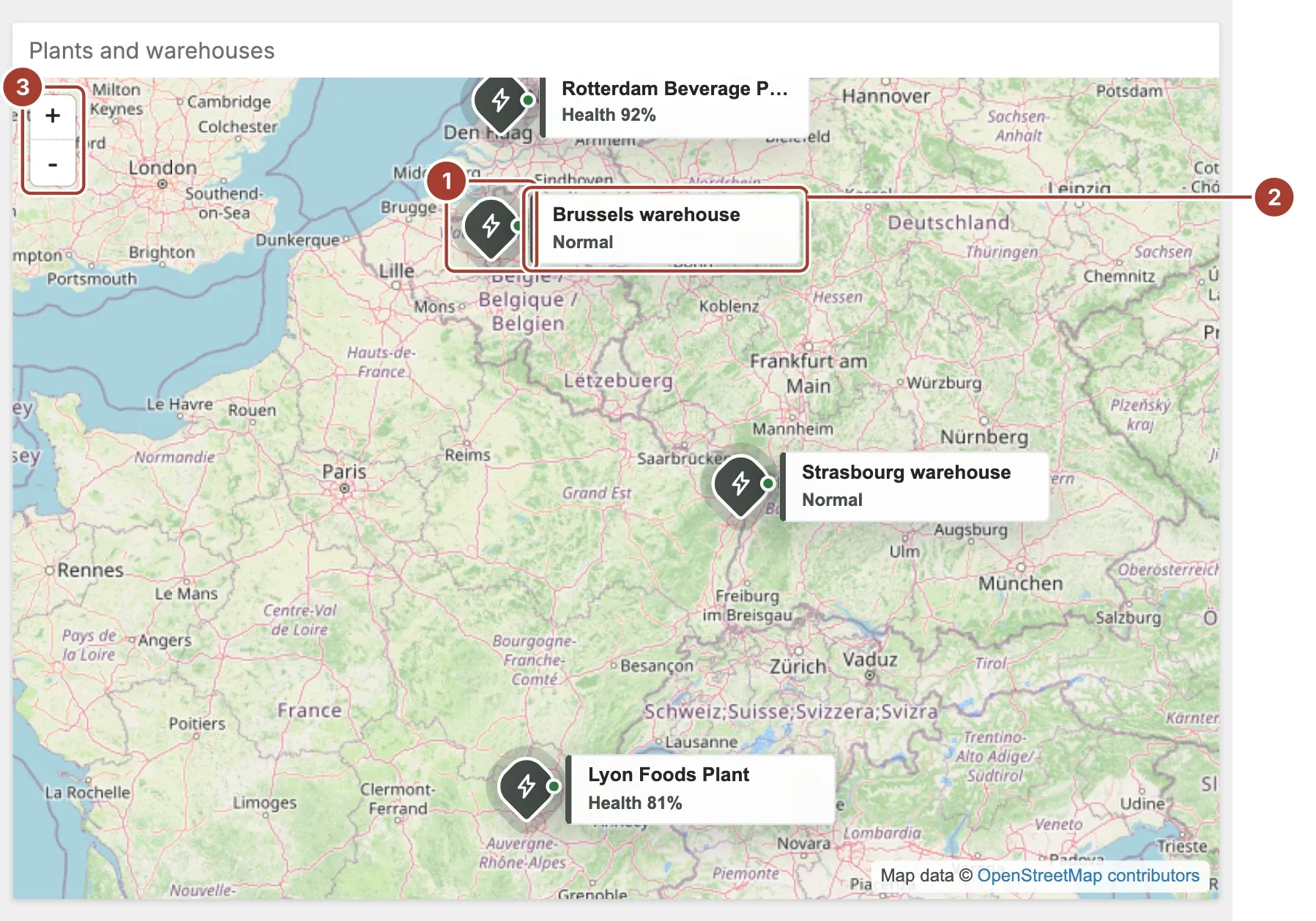
- Marker. One per row. Its colour and icon follow the technology in the tooltip text (solar, wind, hydro or other), and the dot on it follows the status or health.
- Label. The site name and one key figure, next to the marker. Point at a marker to open a card with all its details.
- Zoom. The + and - buttons. You can also zoom with the mouse wheel and drag the map to move it.
When the map is set to filter the other items of the dashboard, select a marker to filter them by that row.
Data fields
| Field | Kind |
|---|---|
| Latitude | Dimension |
| Longitude | Dimension |
| Tooltip | Dimension |
Latitude and Longitude are required and must be numeric fields (integer or decimal), in decimal degrees. Rows without a valid number on both are left off the map. Tooltip is a text field. With the OpenStreetMap provider, the item reads it as parts separated by |:
Site|Technology|Status|Label: value|Label: valueThe first part is the site name, the second the technology, the third the status. The parts after that are Label: value pairs; the item uses those labelled Power, Production and Health. For example Meridian Rotterdam|Plant|Normal|Production: 1,240 u/h|Health: 92%. A status such as Normal, Risk, Alarm or Down, or a health figure (below 70 is critical, below 85 is a warning), sets the colour of the dot. A tooltip with only a name is shown as it is.
Settings
| Setting | Values | Default |
|---|---|---|
| Provider | Google, Bing, OpenStreetMap | Bing |
| Type | RoadMap, Satellite, Hybrid | RoadMap |
| Display mode | Markers, Routes, All | Markers |
| API Key (Bing/Google) | Text | — |
| OpenStreetMap Tile URL | Text | https://tile.openstreetmap.org/{z}/{x}/{y}.png |
| OpenStreetMap Attribution | Text | OpenStreetMap contributors |
- Provider picks the map service. Bing and Google need an API key from that service in API Key (Bing/Google). OpenStreetMap needs no key.
- Type chooses a road, satellite or hybrid map. It applies to Bing and Google.
- Display mode shows the rows as Markers, as one Routes line drawn through them in data order, or All. Sort the data by time or by stop to draw the route in the right order. When other items are filtered by this map, the markers are always shown.
- OpenStreetMap Tile URL is the address the map images come from, with
{z},{x}and{y}for the zoom level and the tile. Change it to use your own tile server, for example on a network without internet access. - OpenStreetMap Attribution is the credit shown in the lower right corner of an OpenStreetMap map.
Related
Was this page helpful?
Evaluating Proxus? See it on your own machines in a 30-minute technical session.